Up Souvenir Mining Spoons Prev Next Slideshow

 Previous image  Next image  Index page  Original Image [River Hill Mine Placerville, CA bowl closeup.JPG - 1.8MB]
Souvenir Mining Spoon Hecla Mine Burke, ID
Souvenir Mining Spoon Bowl Hecla Mine Burke, ID
Placerville1849
River Hill Mine Placerville, CA
River Hill Mine
  River Hill Mine Placerville, CA bowl closeup.JPG - SOUVENIR MINING SPOON RIVER HILL MINE PLACERVILLE CALIFORNIA - Sterling silver souvenir spoon, lightly engraved in bowl above engraved depiction of mine and structures RIVER HILL MINE and below PLACERVILLE, CAL., handle finial has California golden bear image with a helical screw shaped handle, sterling mark on reverse, 5 7/8 in. long, 21.9 grams (Placerville is the county seat of California’s El Dorado County.  The town played a key role as the central hub for the Mother Lode region’s mining operations.  After the discovery of gold by James W. Marshall in 1848 in nearby Coloma, California some eight miles north of Placerville, the small town of Placerville was known as Dry Diggins after the manner in which the miners moved cartloads of dry soil to running water to separate the gold from the soil. With the Gold Rush riches came problems and later in 1849, the town earned its more common historical name, Hangtown, because of the numerous hangings that occurred there.  In 1854 the town’s name was changed to a friendlier-sounding Placerville and the town was incorporated.  At the time of incorporation, Placerville was the third largest city in California, a testament to the town’s importance to the development of the Mother Lode with its many services, transportation of goods and people, lodging, banking, market and general store.  The Placerville District includes the placer deposits here and in the adjacent Smith Flat, Diamond Springs, Texas Hill, Coon Hollow, and White Rock areas as well as the lode mines of the Mother Lode belt.  The lode-gold deposits are massive quartz veins as much as 20 feet thick with numerous parallel stringers. The ore bodies are low to moderate in grade (1/7 to 1/4 ounce of gold per ton), but the veins have been mined to depths of 2000 feet. The ore contains finely disseminated free gold and small amounts of pyrite. The veins occur chiefly in slate.  The River Hill group of mines, which included the Bell, Gentle Annie, Ball Consolidated, Lucky Star, Lyon and New Era, was located on 178 acres of the Mother Lode, one and one-half miles northwest of Placerville.  Originally worked around 1865 and then from 1890 to 1906, these mines were very rich, and produced quite a large amount of gold. Five parallel veins, with ore shoots up to twenty feet in width and 150 feet in length, were developed by 1550-foot and 600-foot inclined shafts, a 2400-foot adit and much drifting. The ore was originally treated in a ten-stamp mill, which was replaced with a twenty-stamp mill in 1901. The Placerville lode mining operations pretty much ceased activity by about 1915.)  
Irish Mag Shaft (C & A Mine)
C & A Shaft Bisbee, AZ
C & A Shaft
C & A Shaft Reverse
C & C Shaft Bowl

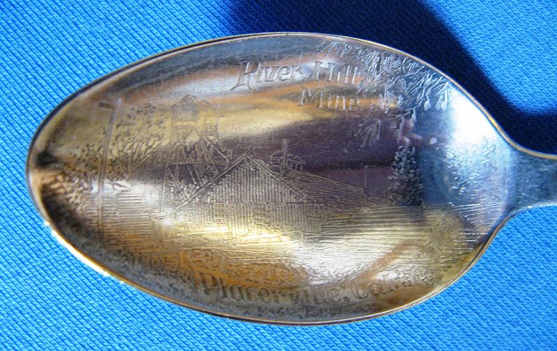
River Hill Mine Placerville, CA bowl closeup | SOUVENIR MINING SPOON RIVER HILL MINE PLACERVILLE CALIFORNIA - Sterling silver souvenir spoon, lightly engraved in bowl above engraved depiction of mine and structures RIVER HILL MINE and below PLACERVILLE, CAL., handle finial has California golden bear image with a helical screw shaped handle, sterling mark on reverse, 5 7/8 in. long, 21.9 grams (Placerville is the county seat of California’s El Dorado County. The town played a key role as the central hub for the Mother Lode region’s mining operations. After the discovery of gold by James W. Marshall in 1848 in nearby Coloma, California some eight miles north of Placerville, the small town of Placerville was known as Dry Diggins after the manner in which the miners moved cartloads of dry soil to running water to separate the gold from the soil. With the Gold Rush riches came problems and later in 1849, the town earned its more common historical name, Hangtown, because of the numerous hangings that occurred there. In 1854 the town’s name was changed to a friendlier-sounding Placerville and the town was incorporated. At the time of incorporation, Placerville was the third largest city in California, a testament to the town’s importance to the development of the Mother Lode with its many services, transportation of goods and people, lodging, banking, market and general store. The Placerville District includes the placer deposits here and in the adjacent Smith Flat, Diamond Springs, Texas Hill, Coon Hollow, and White Rock areas as well as the lode mines of the Mother Lode belt. The lode-gold deposits are massive quartz veins as much as 20 feet thick with numerous parallel stringers. The ore bodies are low to moderate in grade (1/7 to 1/4 ounce of gold per ton), but the veins have been mined to depths of 2000 feet. The ore contains finely disseminated free gold and small amounts of pyrite. The veins occur chiefly in slate. The River Hill group of mines, which included the Bell, Gentle Annie, Ball Consolidated, Lucky Star, Lyon and New Era, was located on 178 acres of the Mother Lode, one and one-half miles northwest of Placerville. Originally worked around 1865 and then from 1890 to 1906, these mines were very rich, and produced quite a large amount of gold. Five parallel veins, with ore shoots up to twenty feet in width and 150 feet in length, were developed by 1550-foot and 600-foot inclined shafts, a 2400-foot adit and much drifting. The ore was originally treated in a ten-stamp mill, which was replaced with a twenty-stamp mill in 1901. The Placerville lode mining operations pretty much ceased activity by about 1915.) Download Original Image
Total images: 377 | Last update: 8/11/23 3:15 PM | Help